location_on Service • Geospatial Data Production & Delivery

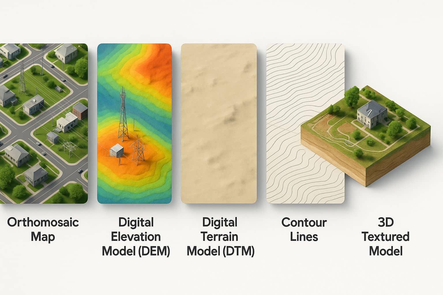
Geospatial Data Deliverables

Transforming raw spatial data into high-value geospatial products, mapping deliverables, and intelligence-ready datasets that support planning, monitoring, engineering, and environmental decision-making.

Geospatial analytics dashboard
location_on
3,500+
Geospatial Deliverables
public
250K+
Hectares Processed
layers
120+
Enterprise GIS Projects
dataset
500+
Spatial Datasets

Service Overview

Our geospatial data deliverables services transform raw survey, satellite, drone, LiDAR, and field data into structured, analysis-ready products that support planning, engineering, environmental management, compliance, and operational decision-making. We standardize spatial information, integrate multi-source datasets, ensure cartographic accuracy, and deliver enterprise-grade GIS products tailored to organizational workflows.

What We Help You Achieve

dataset

Reliable Spatial Data

Access high-quality geospatial datasets prepared for analysis, planning, and operational use with full traceability and accuracy documentation.

trending_up

Improved Decision Support

Transform complex geographic information into practical intelligence and actionable insights for strategic planning and operations.

settings_suggest

Efficient Data Management

Centralize and organize spatial information into structured, scalable GIS systems enabling seamless integration and long-term stewardship.

Core Capabilities

Spatial data production workspace
map

Spatial Data Production

Generation of orthomosaics, Digital Elevation Models (DEMs), Digital Terrain Models (DTMs), Digital Surface Models (DSMs), thematic maps, spatial databases, and geospatial intelligence products tailored to project requirements and industry standards. Full quality assurance and accuracy certification included.

public

Enterprise GIS Deliverables

Development of enterprise-ready spatial datasets, GIS databases, dashboards, reporting frameworks, and decision-support systems supporting long-term operational and planning objectives. Integration with existing organizational GIS infrastructure, API connectivity, and scalable data architecture.

Enterprise GIS platform interface

Intelligence Workflow

satellite_alt
Data Acquisition

Drone, satellite, LiDAR, field surveys, and multi-source data collection.

build_circle
Data Processing

Photogrammetry, point cloud processing, normalization, and standardization.

analytics
Spatial Analysis

Geospatial analysis, thematic interpretation, and intelligence generation.

verified_user
Quality Assurance

Accuracy validation, geometric verification, completeness checks.

file_download
Deliverable Production

Packaging, documentation, formats, and enterprise distribution.

Deliverables

map

Orthomosaic Maps

High-resolution georeferenced aerial imagery mosaics.

terrain

DEM / DTM / DSM

Digital terrain and surface elevation models.

database

GIS Databases

Structured spatial databases and data warehouses.

dashboard

Spatial Dashboards

Interactive web-based GIS visualizations.

description

Contour Maps

Topographic line visualizations and elevation profiles.

article

Thematic Maps

Specialized mapping products for analysis themes.

file_present

Geospatial Reports

Technical documentation and analytical reports.

lightbulb

Intelligence Products

Decision-support outputs and analytical insights.

Technology Ecosystem

ArcGIS Pro QGIS PostGIS GeoServer Google Earth Engine Pix4D Agisoft Metashape Python Geospatial SDI Platforms

Applications

eco
Environmental Monitoring
apartment
Infrastructure Planning
water_drop
Watershed Management
badge
Land Administration
router
Utility Mapping
location_city
Urban Planning
anchor
Coastal Intelligence
agriculture
Agriculture & Resources
warning
Disaster Risk Assessment

Need Reliable Geospatial Data for Your Next Project?

Access professionally generated spatial datasets, GIS products, mapping deliverables, and environmental intelligence outputs tailored to your operational and strategic needs.